More Wet Weather Through Second Half of the Week

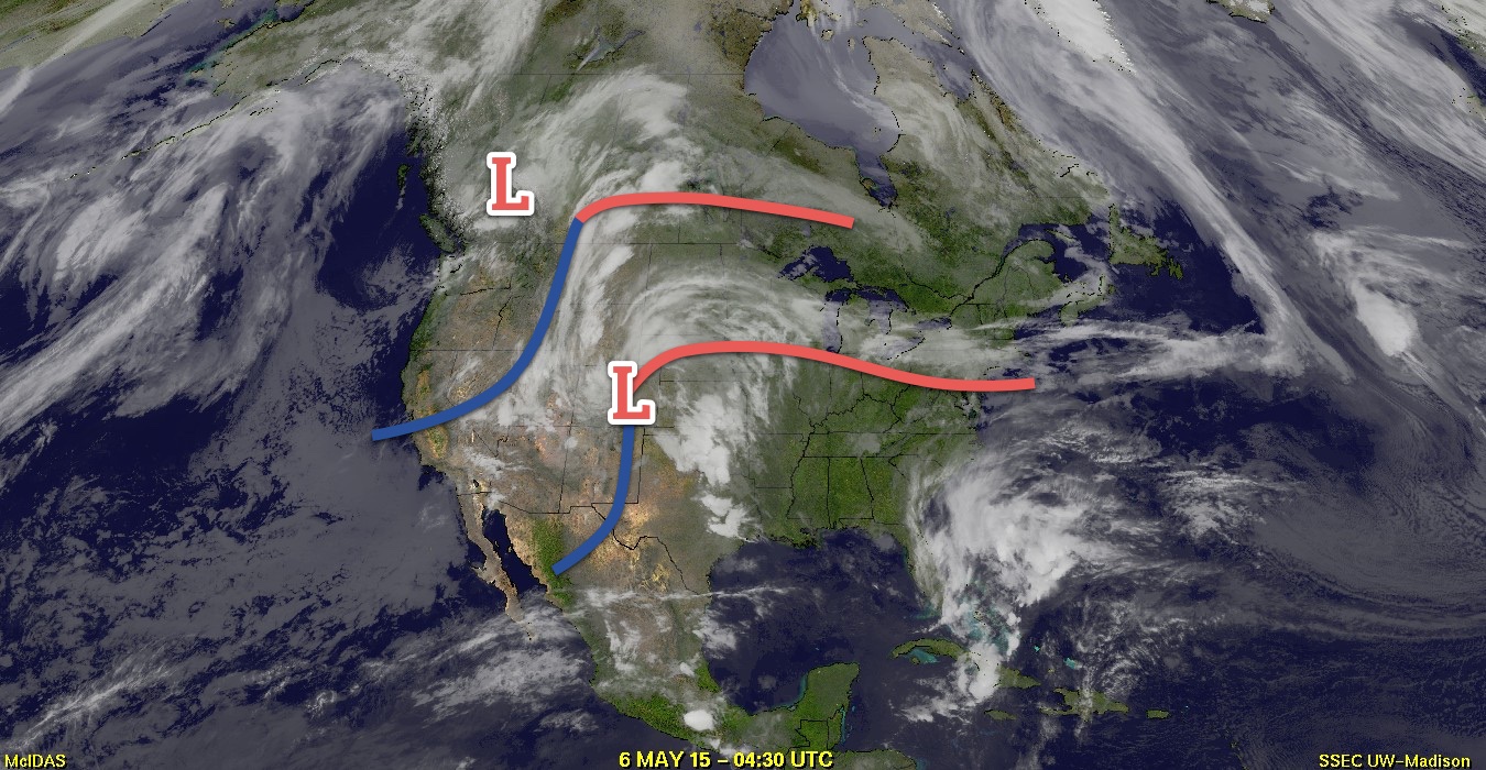
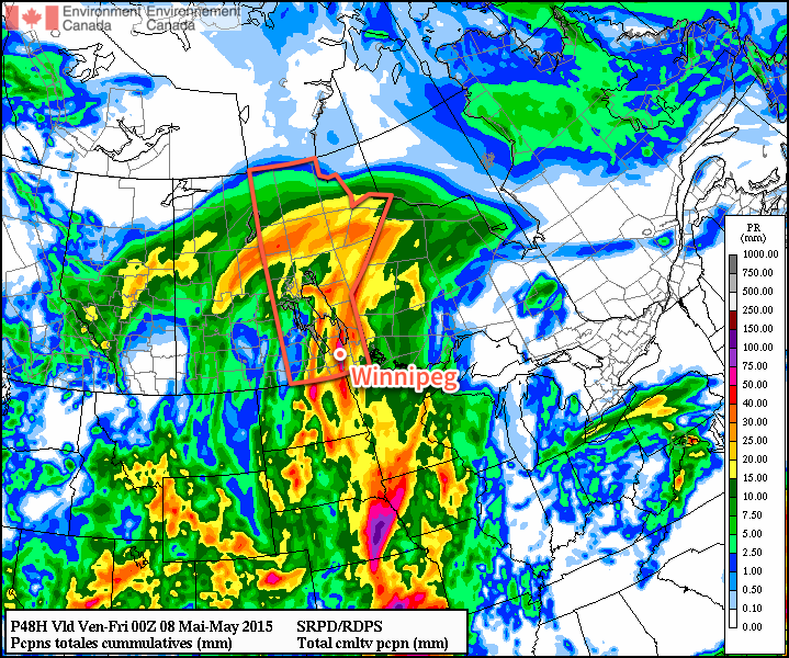
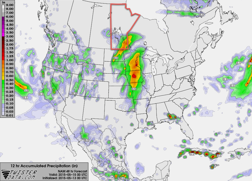
More wet weather is on the way to Winnipeg & the Red River Valley as a slow-moving upper-level disturbance bears down on Southern Manitoba. The bulk of the rainfall associated with this next system will be quite a bit more concentrated than last week’s Colorado Low with much of the precipitation being produced by a single, relatively narrow band of moderate rainfall sliding across the region.

Winnipeg will see a high of around 12°C today with cloudy skies through the day. Shower activity will push northwards through the Red River Valley over the morning hours bringing a decent chance of some rain to Winnipeg by mid-to-late afternoon. Winds will be breezy out of the southeast at around 30km/h with a bit of gustiness on top.

Clouds will stick around tonight as the temperature drops to around 7°C with a continued slight chance of showers through much of the overnight period. The next disturbance will move into Southern Manitoba late overnight, spreading rain from SW to NE starting near the Pilot Mound/SW RRV region and lifting towards Winnipeg.

NAM 12hr. QPF valid 00Z Friday May 15, 2015
The NAM is forecasting around 10-15mm of rain for much of the Red River Valley on Thursday, with some areas seeing as much as 20-25mm.

Thursday will start off as a fairly rainy morning, then see rain taper off from west to east through the afternoon. Skies will remain cloudy through the day with winds out of the east. Expect a high near 13°C. The low on Thursday night will be around 7°C under mainly cloudy skies.

When all is said and done, it’s possible we’ll see somewhere from 10–20mm of fresh rain, however this entire system may end up shifting slightly further west which would leave the Red River Valley fairly dry until remnant showers pass through on Thursday night. We’ll be sure to keep tabs on things as they develop through the day and update with the most likely outcome later tonight.

Friday will bring a break from the gloomy weather as things clear out through the morning, leaving us with sunshine and a high near 19°C and light winds.

Long Range

This weekend will bring another disturbance through the region that has the potential to produce a significant amount of rainfall – 25–50mm – however there’s still a lot of uncertainty associated with the system and many divergent model solutions at the moment. It will likely be a generally unsettled week at best, and potentially a downright rainy one at worst. Some forecasts are showing some fairly favourable convective parameters on Saturday that would hint towards the first significant thunderstorm day of the year, but a decent capping inversion looks to keep things at bay as long as the current forecasts hold out.

Colorado Low Brings Major Rainfall to Southern Manitoba

While Southern Manitoba has seen glancing blows from true Colorado Lows a few times over the past couple years, Winnipeg is in the middle of a multi-year drought with the last direct hit from a Colorado Low in memory occurring in November 2012.[1] Responsible for some of the biggest synoptic storms[2], Colorado Lows are a major weather system that often produce pretty much everything: thunderstorms, heavy rain, light showers, overcast & drizzly conditions, freezing rain, heavy snow and/or blizzard conditions.

Imagery of Developing Colorado Low
This satellite image from early this morning shows the developing Colorado Low over…Colorado. Who would have thunk?

Today will see the arrival of a Colorado Low that will dominate the weather over Manitoba for the coming few days. Southern Manitoba will escape most of the nasty weather associated with this system with just rain expected – albeit a fair amount – while Northern Manitoba gets slammed with heavy snow, freezing rain and strong winds.

Wednesday

Wednesday
24°C / 15°C
Increasing cloudiness then showers with the risk of a thunderstorm

Today will be a relatively pleasant day despite the imminent arrival of the Colorado Low. While today will start off with a little bit of sunshine, high cirrus will move in through the morning with thicker cloud arriving this afternoon. Winds will be out of the south to southeast at around 30–40km/h with some gustiness on top of that. Shower activity – with the risk of thunderstorms – will work its way northwards out of the Dakotas through the day into the Red River Valley. Temperatures will be quite mild with highs around the 23–24°C mark.

Heading into the evening, main band of showers associated with this system will spread across Southern Manitoba bringing rain with a slight chance of an embedded thundershower to the region. Rainfall amounts through the Red River Valley will likely be highly variable thanks to the convective nature of the precipitation; in general the “safe” guess at this point is somewhere in the 15–25mm range…or so. I don’t believe amounts will be much higher than that, but depending on a whole bunch of factors, amounts could end up in the 5–10mm range instead. Unfortunately, with such highly convective systems, these things are almost impossible to forecast until much closer to the event, so we’ll be providing updates in the comments below as well as on Twitter and Facebook. The showers will persist through the night as the temperature dips down to around 14 or 15°C.

Thursday

Thursday
17°C / -2°C
Showers

Tomorrow will be a fairly wet day with more shower activity, potentially quite heavy at times, lasting much of the day before finally beginning to taper off in the evening. Our high temperature will only be around 17°C with some light southerly winds flipping to the northwest in the afternoon to around 40km/h. Rainfall amounts, again, could be quite variable thanks to the convective nature of things and exactly how the system matures.

RDPS Forecast Precipitation Accumulations by Thursday Evening
The RPDS weather model is bullish on convection and producing over 2″ of storm-total rainfall for the Red River Valley. This is likely too much.

There are really two possible outcomes:
1. General rainfall amounts near 10mm with convective amounts once again near 20–30mm in the Red River Valley. This would assume a general “rainy” area with embedded convective storms.
2. Very little rain as energy reconsolidates around a low developing in North Dakota and precipitation pushes off to our south and east.

I don’t think Plan #2 is particularly likely, but it should be noted. Again, we’ll provide updates heading forward below in the comments as this entire system becomes a more developed.

The gusty northwesterly winds will taper off in the evening as the precipitation moves out. Expect the temperature to drop to a very chilly –2°C.

Friday

Friday
8°C / -3°C
Mainly sunny and cool

Friday will be a pretty benign day marked by temperatures well below normal for this time of year as our high struggles to climb to 8°C with an Arctic ridge building into the region. Winds will be breezy out of the northwest at around 30km/h making for a chilly day all around.

Clear skies will continue on Friday night as the temperature dips to around –3°C.


  1. I checked through our archives and chatted with a few other people, and that seems to be the general “last hit” agreement. Feel free to leave a comment if you can recall one more recently.  ↩
  2. Synoptic storms are large low pressure systems that impact across hundreds to thousands of kilometres, unlike convective storms which impact small areas.  ↩

Hot Weather Continues

The summer-like temperatures seen in Winnipeg over the past couple days will continue into the weekend with daytime highs 10°C above normal. A cold front will finally push through on Saturday evening, bringing an end to the exceptional warmth and ushering in a return to seasonal temperatures.

Today will be a gorgeous day in the Red River Valley with light winds and daytime highs near 25°C with a bit of a southwesterly wind. Expect a few clouds tonight with a low near 10°C.

Tomorrow will be a more interesting day as a more organized southerly flow develops over the Red River Valley ahead of an approaching low pressure system. Temperatures will climb to around 27°C while a meager amount of moisture pools through the Red River Valley ahead of an approaching trough. As the trough moves into the Red River Valley, it’s looking quite possible that we may see a few thunderstorms develop, however the chance is largely conditional.

Winnipeg Forecast Sounding for the afternoon of Saturday May 2, 2015
This forecast sounding valid Saturday afternoon for Winnipeg from the NAM model shows a deep layer of instability, adequate moisture and favorable shear for thunderstorm development.

Given the fairly low amount of moisture available, cloud bases would likely be very high; the forecast sounding indicates cloud bases near 10,000ft which would mean the biggest threat from the storms would be strong wind gusts. Some hail might be a threat further south in North Dakota, perhaps sneaking onto extreme southeastern Manitoba, but overall it looks more like we’ll see a few weak thunderstorms develop capable of producing some fairly gusty winds. The overall environment, save for the lack of moisture, looks quite favorable for the development of the storms, though. Winds will generally be out of the south to southwest at around 30 gusting 50km/h with a slight chance for some 50 gusting 70km/h winds in the afternoon.

Some cloud will linger overnight as temperatures dip to around 9°C with winds relatively light out of the west to northwest.

Sunday will bring a bit of cloudiness and slightly cooler temperatures with a daytime high of “only” 19°C. Winds could be gusty out of the northwest for a few hours beginning in the morning before settling down to 30 gusting 50km/h for the afternoon. Sunday night looks mainly clear with a low near 5°C.

Elsewhere in Weather News: March 28th, 2015

First Significant Severe Weather Event of the Season Strikes Oklahoma

This past Wednesday severe storms erupted across much of Oklahoma bringing with them very large hail and even tornadoes. It was the biggest severe weather day this year in the states, up to now (but many more are to come). A surface low was located in central Oklahoma with dryline extending southward, cold front crashing south from the north side of the low, and a warm front extending northeastwards from the low. There were two main focus areas for the storms – along the dryline and near the triple point/along the warm front. A moderate risk was issued by the SPC and covered the areas of concern. The outlook also included a 5% tornado risk with 45% hatched hail probabilities. A moderate jet streak was in place with dewpoints in the high teens, which together provided sufficient shear and CAPE for supercells.

[map type=”terrain” autofit=”1″ disable_scrollwheel=”1″] [pin]Sand Springs[/pin] [pin]Moore[/pin] [/map]

As expected, several storms initiated on Wednesday afternoon and grew into supercells. Two supercells were of most concern before storms consolidated into squall lines: one near Tulsa and one near Oklahoma City. The storm that approached Tulsa showed strong rotation on radar early in its lifetime –a tornado warning was able to be issued well before it hit the city. By the time it reached a suburb of Tulsa, Sand Springs, a tornado touched down and tore through a trailer park. In addition to that, hail, the size of tennis balls, were reported in Tulsa’s metro region as the supercell’s hail core passed over the city. The tornado (preliminary rating of EF-2) injured over a dozen people and one person lost their life in the trailer park.

Aerial view of the damage to the trailer park in Sand Springs. (Source: Tulsa World)

The Oklahoma City storm fired off the dryline initially but then got undercut by the cold front – meaning it had little tornado potential. Interestingly enough, the supercell was able to catch up to the cold front and interact with it, enhancing the vorticity in the area – likely being a contributing factor to the formation of the tornado. With this mesoscale interaction playing a significant part in the cause of the tornado, not much lead time was provided to residents (it happened quickly). Unfortunately the twister (preliminary rating of EF-1) touched down in the city of Moore, OK which got hit by a devastating twister in 2013 and had seen two other strong tornadoes since 1999. No injuries were associated with this one, thankfully.

Compilation of radar images before/during/after the Moore tornado showing the storm's interaction with the cold front. (Image compilation by @VORTEXJeff / Twitter)
Compilation of radar images before/during/after the Moore tornado showing the storm’s interaction with the cold front. (Image compilation by @VORTEXJeff / Twitter)

The pattern could become active again by the middle of next week, but it is still too early to be certain. April to late May is typically the busiest time of the year for severe weather in the Southern US Plains, due to plentiful moisture before the jet stream shifts further north for the summer.